Great Local Rides
Ride for the exercise. Ride for the environment. Ride for the family, or ride for fun. Just Ride. We've got a great variety of rides right here in our backyard, from the trails of the Blue Hills or Wampatuck State Park, to the roads along the coast and down to the Cape. GET OUTSIDE. GET OUT AND RIDE. Then come tell us about it.
MBTA Bicycle Information - Bikes are allowed on the T, ferries, buses and the commuter rails. This is a link to the information you need to know about taking your bike on the MBTA. Many of the areas below are accessible by public transportation so take "The T" to your ride the next time and you'll feel "Green" all over
Mountain Bike Riding Areas
Trailforks - https://www.trailforks.com/ - a new site we found that you can look up mountain bike traisl almost anywhere you may be going. Plus if you download the app you can use it while on your ride in case you take a wrong turn.
Nemba - For detailed list of recommended Massachusetts mountain bike areas, including site locations, directions, trail descriptions, history, and regulations check out the NEMBA (New England Mountain Bike Association) website, www.nemba.org. Some of the areas around the our shop on the South Shore are listed below. (Please support NEMBA with your membership. Plus join them when you see a "Trail Maintenance Day" at the area you ride. Look for membership details on NEMBA's website.)
SE Mass NEMBA Riding Zone - Great page from the Southeastern NEMBA Chapter website for places to ride in SE Mass
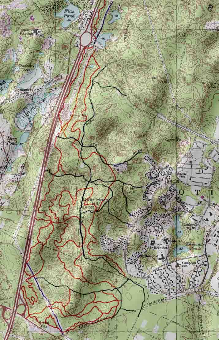
Wompatuck State Park, Hingham MA- click here for more info from NEMBAor for the new 2015 PDF Trail Map
Blue Hills Reservation, Milton MA- click here for more info from NEMBAor for a PDF Trail Map
Ames Nowell State Park, Abington MA- click here for more info from NEMBAor for a PDF Trail Map
Borderland State Park, Easton/Sharon MA- click here for more info from NEMBAor for a PDF Trail Map
Myles Standish State Forest, Carver MA- click here for more info from NEMBAor for a PDF Trail Map
Otis/ Crane WMA on Cape Cod, Bourne/Falmouth MA- click here for more info from NEMBAor for a PDF Trail Map - additonal map here
Massassoit State Park, E. Taunton MA- click here for more info from NEMBAor for a PDF Trail Map
Freetown State Forest, Assonet MA- click here for more info from NEMBAor for a PDF Trail Map
Trail of Tears, Barnstable MA- click here for more info from NEMBA or for a PDF Trail Map
Whitney Thayer Woods, Hingham/Cohasset MA- click here for more info from NEMBA or for a PDF Trail Map
World's End, Hingham MA- click here for more info from NEMBA or for a PDF Trail Map
Road Riding Loops, Paths or Rides
New England and especially the South Shore has many scenic and fun rides to take both on the road and paths. Below you will find some info on rides that are near The Link but many of the sites are a good source of finding rides for wherever you go in the area.
Bicycle Link - Cohasset Loop 29 Miles - This is a ride from the shop and return that goes through Wompatuck and out to the ocean and back
Mass Bike - Comprehensive list of Massachusetts bicycle paths and trails – both current and future! Links to MassBike website. (Please support MassBike with your membership, details on their website.)
Traillink by Rails-to-Trails Conservancy - The Rails-to-Trail directory site of trails and paths for riding. We have posted a link to Trails near the Weymouth area. This is a good resource for path riding anywhere in the US
Cape Cod Bike Guide - A good site to find where to ride on the Cape which has great paths for the recreational rider and more
Shining Sea Bike Path - The Shining Sea Bikeway, in Falmouth, follows the route of a former railroad line run by the New York, New Haven and Hartford Railroad Company. The 10.7-mile Shining Sea Bikeway—the only bikeway on Cape Cod to feature a seaside section—boasts beautiful vistas of marshes, rivers, and the sea. The path goes from Rtes 28A and 151 to Wood Hole, MA
Click here for Shining Sea Bike Path Map
South Shore Coastal loop- This is an old standby ride from Map My Ride. Incuding coastal views, light houses and harbors
Map your own ride- Research others rides or map your own at this site
Department of Conservation and Recreation (DCR) - Info about biking at any of the DCR Parks
Rubel Bike Maps - Local bicycle maps, the best regional bike maps anywhere! These are made by a local biking enthusiast, Andy Rubel, and the input he gets from riders. Featuring on-road routes and mtn-bike areas too. We have these maps in stock for purchase at the shop.
Local Group or Community Rides
Tell us about your local ride and we'll post it to the site